


Image: METAL
Summary
- On October 14, Google Research published a technical report on its Gemini-based Geospatial Reasoning agent and expanded experimental access through Google Earth and an agent-to-agent (A2A) service.
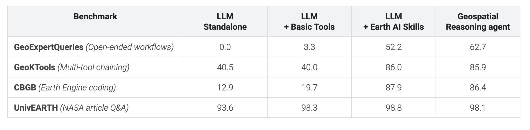
- On the open-ended expert benchmark GeoExpertQueries, Gemini 3.8 Flash scored 0 with no tools, 3.3 with basic tools and 62.7 as the full agent, while GeoKTools rose from 40.5 to 86.0.
- The WHO Regional Office for Africa used the agent early in an Ebola outbreak to identify 48 exposed settlements and more than 45,500 at-risk people within minutes.
Google Research on October 14 published a technical report on a geospatial reasoning agent that analyzes Earth data, and widened experimental access to it. Built on Gemini, the agent wraps satellite, weather, flood and population foundation models as tools, and when it receives a question it draws up an analysis plan before executing anything. According to the report, on a benchmark of open-ended tasks designed by experts, a large language model (LLM) with no tools scored 0 and a model with basic tools such as web search and maps scored just 3.3, while the agent scored 62.7. Google is opening trial use to a limited set of users through an interactive deep-analysis feature inside Google Earth and an agent-to-agent (A2A) service for developers.
The starting point is a weakness of general-purpose models. Shravya Shetty, a Distinguished Engineer at Google Research, and Luke Barrington, a product director, wrote in a blog post that planet-scale datasets are so large, and map and satellite formats so specialized, that combining them accurately is difficult without careful multi-step planning. The agent therefore connects Gemini to WeatherNext, flood forecasting, the Population Dynamics Foundation Model (PDFM), AlphaEarth Foundations and the Remote Sensing Foundations models, and pulls in place, routing, air-quality and rooftop solar potential data from Google Maps Platform as well as Google Earth Engine, Data Commons and Dataset Search.
The core of the design is context management. Earth AI capabilities are packaged as modular skills that are called only when a question needs them. Before running complex operations, the agent writes a step-by-step analysis plan, picks fallback datasets where local data is thin, and processes large map layers in a dedicated workspace outside the model's context window. Every answer shows the plan and the data sources used, so experts can check assumptions or swap datasets. Users can upload their own data as CSV tables, custom boundaries (GeoJSON) or cloud tables and join it with Google's global models.
The evaluation compares four configurations on the same underlying model. The 39-page report tests Gemini 3.8 Flash and Gemini 3.1 Pro each as a standalone LLM, an LLM with basic tools, a configuration with Earth AI tools but no upfront planning, and the full agent with a planning stage, across four benchmarks. GeoExpertQueries, which Google built for the report, is a set of 101 open-ended tasks left after unsolvable ones were filtered out of 132 expert-written problems, each paired with a golden workflow agreed by three independent experts. GeoKTools, also new, has 305 queries drawn from 92 templates that can only be solved by correctly choosing one to four of 24 tool types. Google released the development splits of both benchmarks to researchers.
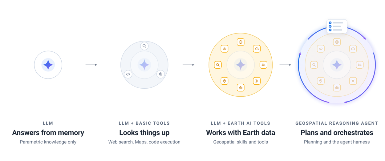
The results point to tools as the biggest differentiator. According to the report's tables reviewed by METAL, with Gemini 3.8 Flash the GeoKTools score jumped from 40.5 for a standalone LLM and 40.0 with basic tools to 86.0 once Earth AI tools were added. On CBGB, an Earth Engine coding benchmark, scores went from 12.9 and 19.7 to 87.9. Upfront planning added 10.5 points on the open-ended tasks, lifting GeoExpertQueries from 52.2 to 62.7, and by domain the largest gain came in natural hazards and crisis resilience, from 45.6 to 66.0. With Gemini 3.1 Pro, however, the agent with a planning stage scored 47.6, 3.2 points below the tools-only configuration at 50.8. On UnivEARTH, a question-answering benchmark based on NASA articles, even a standalone LLM scored 93.6, and Google concluded the benchmark is saturated because the source text is public on the web. Because GeoExpertQueries scores come from an autorater that measures agreement with expert workflows rather than whether the final answer is correct, Google describes the agent's output as a draft for experts to review.
The most concrete numbers from field testing came from public health. At the start of the 2026 Ebola outbreak in the Democratic Republic of the Congo, the Dakar-based Emergency Preparedness and Response Hub of the WHO Regional Office for Africa (WHO AFRO) cross-referenced forest loss from satellite imagery, mining sites from maps and web data, and population data to map remote mining corridors with heavy human movement. Within minutes it identified 48 exposed settlements and more than 45,500 at-risk people, work that would normally take weeks. Local responders used the results to deploy mobile laboratories ahead of time and coordinate border surveillance. The epidemic modeling unit at the DRC's National Institute for Biomedical Research (INRB) used the Planetary Prediction Engine to estimate weekly the risk of Ebola spreading into uninfected areas. "Mobile populations like miners move faster than traditional paper surveillance can track, creating dangerous blind spots," said Dr Etien Koua, hub coordinator for WHO AFRO Emergency Preparedness and Response. "Earth AI fills those gaps with satellite and mobility signals, moving us from reactively chasing a virus to actively forecasting where it will strike next."
Disaster preparedness also moved to a different time scale. The aid group People in Need analyzed 14 historical cyclone paths to find highly exposed villages. "Instead of days of manual GIS work, we identified high-exposure villages in minutes, freeing up time for life-saving anticipatory action," said Alonso Gonzales, GIS and remote sensing coordinator. The cash-transfer charity GiveDirectly uploaded custom boundaries to calculate population exposure by wind-speed zone during Tropical Cyclone Maila and to gauge tornado damage in Mississippi, cutting crisis scoping from days to minutes. The Milken Institute matched a list of more than 1,500 candidate buildings with Google Maps Platform's Solar API and census data to choose sites for community resilience hubs, and advertising group WPP combined population dynamics insights with its own data to improve the performance of geospatial marketing campaigns.
The announcement builds on earlier work. The agent also powers the Planetary Prediction Engine that Google recently introduced. Given a user's local outcome data, such as regional disease rates, crop yields or power outages, it selects relevant population and environmental signals on its own and trains machine learning models for spatial prediction, high-resolution downscaling and forecasting. In Google's public health research, combining population and satellite signals improved predictions of health outcomes by 12% over demographic baselines and made maps eight times finer. METAL previously reported that Google Research published public health case studies for geospatial AI, and this report is the first to put the agent behind those cases on a systematic benchmark. Feedback from partner testing led Google to add road-network routing, support for larger uploaded datasets and better discovery of authoritative local data.
Seen through an engineer's eyes, the report's conclusion is about wiring, not model size. Adding specialized tools to the same model more than doubled its scores, and the planning stage paid off only on problems without a single correct answer. The report notes that within the full agent, the newer Gemini 3.8 Flash outperformed Gemini 3.1 Pro on GeoExpertQueries and GeoKTools at lower cost. For planet-scale analysis, the edge comes not from a bigger model but from designing which data to call and in what order. Google is accepting trial users through an interest form and an early access pool.



Comments